The History and Archaeology of Cathedral Square Peterborough 1st Edition by Stephen Morris ISBN 9781784916626
Original price was: $50.00.$25.00Current price is: $25.00.
The History and Archaeology of Cathedral Square Peterborough 1st Edition by Stephen Morris – Ebook PDF Instant Download/Delivery: 9781784916626
Full download The History and Archaeology of Cathedral Square Peterborough 1st Edition after payment
Product details:
ISBN 13: 9781784916626
Author: Stephen Morris
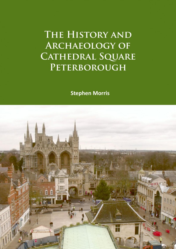
Northamptonshire Archaeology, now MOLA Northampton, was commissioned by Opportunity Peterborough (Peterborough City Council) to undertake archaeological work ahead of an improvement scheme centred on Cathedral Square, the historic centre of Peterborough. The construction of two triangular arrays of fountains in the central part of Cathedral Square formed the core of the archaeological investigation, which was undertaken from November 2008 to August 2011. The archaeological work identified a succession of stone surfaces from the creation of the market square in the 12th century through to the 19th century. The cobbled surface of the original market square was overlaid by an accumulation of dark organic silts, containing finds dating through to the 16th century. At the start of the 15th century the parish church of St John the Baptist was constructed over the western half of the medieval market square with a cemetery immediately to the west of the church. Following the closure of this cemetery by the later 16th century, a small area of floor surfaces were the probable remains of a building, perhaps the Sexton’s house, at the north end of Butchers Row. On the south side of the market square there were the remains of a rectangular stone building, dated to the late 15th to 17th centuries, perhaps containing shops. Between this building and the church, a raised area of rubble was probably a remnant of the plinth for the recorded market cross. The late 17th century saw the construction of the still extant Guildhall to the east of the church. The raising of the ground level and resurfacing of the square was probably contemporary with the Guildhall. This would have involved the removal of all existing buildings on the south side of the square, as well as the removal of the market cross. In the late 18th or early 19th centuries the square was again raised and resurfaced, now with pitched limestone. Shallow gutters between the pavement and the road facilitated drainage. A surface of granite sets of the 19th-century survived in a few places below the late 20th-century slab pavement, which has now been replaced by the fountain development.
The History and Archaeology of Cathedral Square Peterborough 1st Edition Table of contents:
1. Introduction
Fig 1.1: Site location
Fig 1.2: Development areas
2. The Norman or West Gate to the Cathedral Precinct in 2009, prior to development, looking east
Fig 2.2: The Church of St John the Baptist and the Guildhall in 2009, Prior to development, looking south-west
Fig 2.3: John Speed’s Map of Peterborough, 1610 (Peterborough Museum)
Fig 2.4: The Guildhall, built in 1671, looking south-west
Fig 2.5: Thomas Eyre’s Map of Peterborough, 1721
Fig 2.6: Miss Frances Pears’ Almshouses (now Harriet’s Tearooms) on Exchange Street, looking north-east
Fig 2.7: The plaque dedicated by the Foeffees to Miss Frances Pears for her funding to assist the aged and infirm of the parish of Peterborough
Fig 2.8: The Gates Memorial, moved from Cathedral Square to Bishops Road Gardens in 1963, looking north
Fig 2.9: Peterborough City hall, built in the 1930s on the newly created Bridge Street, looking east
Fig 2.10: Cathedral Square, looking east, from the tower of the Church of St John the Baptist in 1919 (the Francis Frith collection)
Fig 2.11: Cathedral Square, looking east, from the tower of the Church of St John the Baptist in 2009
3. The Archaeology of Cathedral Square
Fig 3.1: Posthole with in situ wooden post, at the east end of Cathedral Square
Fig 3.2: Survival of the 12th-century Market Square surface
Fig 3.3: de Bec’s Market Square surface, sealed by dark silt of the 12th to 17th centuries, Cathedral Square, looking west
Fig 3.4: Gas trench at the cathedral west gate, showing stone foundations of the 12th to 14th centuries, looking north-east
Fig 3.5: Foundation of the south turret of the 14th-century west gate, partially disturbed by services of the early 20th centu y, looking south-east
Fig 3.6: Buildings at the east end of Cathedral Square
Fig 3.7: Medieval and post-medieval street frontages along Cumbergate
Fig 3.8: Dark silt over de bec’s market square surface, on the north side of cathedral square
Fig 3.9: De Bec’s market square surface, with overlying dark silt and showing later resurfacing
Fig 3.10: Early churchyard wall, north side of Church Street, looking north
Fig 3.11: Churchyard burials to the west of the church
Fig 3.12: The skull of burial HB1
Fig 3.13: The femurs of burial HB6 overlying the feet of one or two earlier burials, HB7
Fig 3.14: Kerb stones edging a pathway of the 15th century, against the stone churchyard wall (right), with the road (left) at a lower level, trench 6
Fig 3.15: The pavement surfaces in Church Street from the 12th to 20th centuries (top) and the pavements in relation to the sunken churchyard (bottom)
Fig 3.16: The fountain array area with the two deeper trenches containing walls and floors of Building 3, looking north-east
Fig 3.17: Extant stone wall of Building 3 (foreground) with robbed wall and floors behind, looking north
Fig 3.18: Building 3, the east wall, foreground, and narrow internal walls and floors behind, built over the levelled remains of Building 1, looking west
Fig 3.19: Pavement and street surface on the west side of Building 3
Fig 3.20: Remains of the 15th-16th-century street monument in Cathedral Square
Fig 3.21: Stone mortar set in the floor of building on Butchers Row, possibly to use as a urinal
Fig 3.22: The sexton’s house, floor layers and possible urinal in section
Fig 3.23: Flagstones at west end of churchyard may outline the location of the sexton’s house at the north end of Butchers Row, looking south towards the surviving burgage tenement buildings on church street
Fig 3.24: The Guildhall in 1896, looking west, showing the row of buildings between the Guildhall and the church
Fig 3.25: The eastern façade of the Guildhall
Fig 3.26: Guildhall stone foundations in fountain drain trench on the east side of the building, Guildhall to right, looking south-west
Fig 3.27: Pitched-stone path of the 17th century, overlaid by a pitched-stone pavement of the late 18th to early 19th century, both abutting the churchyard stone wall (right), looking west
Fig 3.28: Street surface of the 17th century, overlaid by the dark silt, cut by a modern pipe trench to the right, Queen Stree , looking south
Fig 3.29: Pitched-stone surface of the late 18th- to early 19th centuries, with underlying make-up layers, sealing the dark silt under Cathedral Square in the east, looking north
Fig 3.30: Pitched-stone pavement with an open gutter along its outer edge, to the south of the church, cut by a Victorian brick culvert, looking east
Fig 3.31: Pitched-stone pavement of the 18th century, cut by a brick culvert of the 19th century, south of the church
Fig 3.32: Pavement at the east end of the churchyard wall, looking west
Fig 3.33: Buildings of the 17th century surviving on Church Street, looking south
Fig 3.34: Buildings between the parish church and the Guildhall
Fig 3.35: West of the Guildhall, a stairwell with steps down to the cellar threshold, Building 8, Cellar 4,
Fig 3.36: North-west of the Guildhall, stone cellar wall and brick floor, Building 7, Cellar 2,
Fig 3.37: Corn exchange; remains of wall and floor of the subterranean toilet, looking east
Fig 3.38: Miss Pears’ almshouses, looking north east, with garden brick wall foundations (foreground)
Fig 3.39: An 18th-century town house on Queen Street, now The Grapevine public house, looking west from Exchange Street
Fig 3.40: Church gateway, north-west corner of the churchyard, looking north onto Exchange Street
Fig 3.41: Churchyard railings on the north side of the church
Fig 3.42: Graffiti on 19th-century lead pipes on the church of St John the Baptist: showing a name, GRAIL, and a date of 1831 (left), and a figure in top hat and tails in a pugilist pose (right)
Fig 3.43: Victorian brick culvert on the north side of Church Street, cutting a pitched-stone pavement of the late 18th to early 19th century
Fig 3.44: Excavated section through culvert, looking north
Fig 3.45: Remnant granite setts of the late 19th to early 20th century, under the Cathedral’s West Gate, looking south
Fig 3.46: Present day Cathedral Square, with the new fountain arrays in use, looking east towards the Cathedral’s West Gate
Table 3.1: Summary of chronology
4. Pottery fabrics
Fig 4.1: Medieval mortar in Barnack limestone (SF79)
Fig 4.2: Octagonal capital or base in Alwalton marble (SF58)
Fig 4.3: Possible corbel, with a half roll
Table 4.2: Other finds quantified by material type
Fig 4.4: Part of respond/jamb (SF60)
Fig 4.5: Part of an octagonal moulding, possibly a step (SF59)
Table 4.3: Other finds by functional category
Fig 4.6: Metal finds (6-16)
Fig 4.7: Leather shoes (17-20)
Fig 4.8: Oates and Green brick (left), Halifax (right) and local Star brick (below)
Table 4.4: Dimensions of complete bricks
Table 4.5: Animal bone fragmentation
Table 4.6: Mammals present
Table 4.7: Birds present
Table 4.8: Animal bone from dark silt sieved samples
Table 4.9: Tooth eruption and wear of main domesticates
Table 4.10: Plant macrofossils, taxa present
5. Discussion
People also search for The History and Archaeology of Cathedral Square Peterborough 1st Edition:
how do the history and archaeology work together
international conference on the history and archaeology of jordan
the history and archaeology of the bible episode guide
the history and archaeology of the bible episodes
the history and archaeology of the bible great courses
Tags: Stephen Morris, History, Cathedral Square Peterborough
You may also like…
History - Archaeology
Between History and Archaeology Papers in Honour of Jacek Lech 1st Edition Dagmara H. Werra

Medicine - Therapy

Uncategorized

Medicine - Clinical Medicine
Queen Square A History of the National Hospital and its Institute of Neurology Simon Shorvon

History - European History

History - Archaeology
Salt in Eastern North America and the Caribbean: History and Archaeology 1st Edition Ashley A. Dumas
Uncategorized
Spanish Cathedral Music in the Golden Age 1st Edition by Robert 9780520376021 0520376021